BaseCamp and contemporary Garmin devices allow the display of custom raster maps/images which reside in the \Garmin\CustomMaps folder located on the GPS (main memory or SD card). These maps are georeferenced and tiled KMZ files more often than not obtained by scanning a paper map to produce a JPG image, geolocating it using Google Earth, exporting it as a KMZ and then tiling it using software such as KMZFactory.
A user wishing to use aerial images as a backdrop for a GPS display can adopt much the same process as that employed to produce custom maps – the GPS is not able to recognise the difference between maps and aerial images as they are both raster scans.
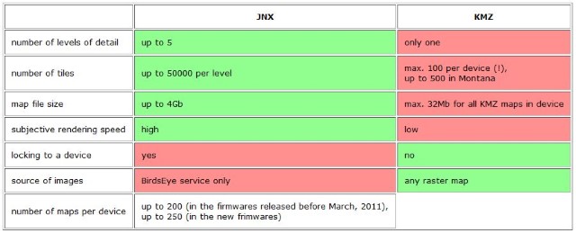
Those particularly interested in using high-resolution satellite imagery and/or detailed proprietary raster maps as overlays used to subscribe to the Garmin BirdsEye service. This took three forms – BirdsEye Satellite Imagery, BirdsEye TOPO and BirdsEye Select, each of which cost about £22 per year per GPS device. Unfortunately, however, the service was discontinued in 2022.
The file extension for BirdsEye images is JNX. They reside in the Garmin\BirdsEye folder that can be found both in main memory and on the SD card. Unsurprisingly, JNX is a so-called tile format, ie large raster maps are divided into smaller rectangular pieces (tiles) to speed up the map rendering.
BirdsEye is supported by most of the more recent Garmin devices including:
Alpha 100, Astro 320/430/900, Colorado 300/400c/400i/400t, Dakota 10/20, Edge 520Plus/530/800, Edge Explore/Touring, Edge 1000/1030/1030Plus, Epix, Etrex 20/22/30/32, GPSMAP 62/64/66/78/86, Montana 600/650, Oregon 200/300/400/450/550, Overlander, Rino 610/650/655, and Zumo XT.
Use of non-Garmin JNX files
JNX files use a proprietary format which is not in general use. That said, the custom maps produced by QMapShack and its associated package QMapTool are generated in JNX format as standard – the need to employ Google Earth for georeferencing, then tiling using independent software is thereby avoided. In the absence of a BirdsEye subscription, a non-Garmin sourced JNX file placed on a Garmin GPS will not load and render unless a firmware patch is installed which modifies the licensing controls. This may be accessed via OpenStreetMap or downloaded directly from the patcher site. It works by removing the limitation on the number of demo-maps displayed and their maximum area. Use at your own risk!