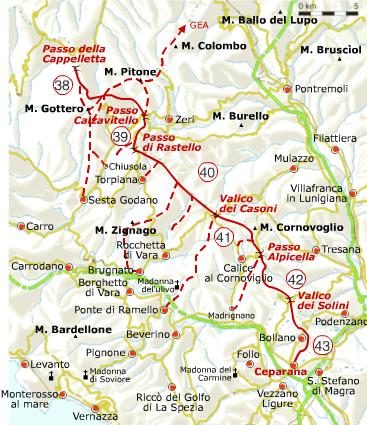
The “Alta Via dei Monti Liguri” (Ligurian High Road) starts at Ventimiglia, crosses the whole of Liguria from West to East and is a major walking route, 440km long. The final section runs roughly along the Liguria/Tuscany border to end at Ceparana where the Vara and Magra rivers meet.
Full details of the route from Passo della Cappelletta to Ceparana can be found on the AVML website. A translation of the description of Stages 38-43 is given below.
The entire route is characterized by alternation of mixed deciduous woods, extensive grasslands intended for grazing (at higher altitudes), and reforested conifer plantations. Monte Gottero (1,640 m), the highest peak in eastern Liguria, is a wildlife oasis in which can be found both common and rare alpine flora. It is also renowned as a viewpoint for long range panoramas. Not far away, Foce dei Tre Confini reminds us that this stretch of watershed was, for a long time, the border between the Republic of Genoa, the Duchy of Parma and the Grand Duchy of Tuscany. Leaving the Calzavitello and Rastello passes behind, one reaches a formidable observation point from which one can see the Apuan Alps and the Gulf of Poets, next to Mount Cornoviglio (1160 m). A short distance away, after passing the characteristic birch forest in Vallecchia, one can visit the beautiful historic centre of Bolano.
From the end of the walk at Ceparana, connections with the Alta Via del Golfo, Montemarcello and Bocca di Magra are being established by the Montemarcello-Magra Park (which can also be reached thanks to the Park’s river boat service).
Further details are as follows:
Stage 38: Cappelletta Pass – Calzavitello Pass
This is a rather long stage that passes through the beech woods of Monte Gottero (1640 meters above sea level). The main route of the Alta Via goes around Monte Gottero to the north, but it is also possible to reach its summit by following the branch (AV2) that climbs along the watershed. From Foce dei Tre Confini to Passo Calzavitello you can follow a direct variant (AV2) which shortens the route by about an hour.
Length: about 11 km
Time: 4.30 hours
Difference in altitude: about 510 metres
Difficulty: E
Maximum altitude: 1408 metres above sea level (Foce dei Tre Confini) or 1640 metres above sea level (Mount Gottero)
Stage 39: Calzavitello Pass – Rastello Pass
Length: 5.6km
Time: 1.45 hours
Elevation gain: about 359 metres
Difficulty: E
Maximum altitude: 1161 metres above sea level (Mount Antessio)
Stage 40: Passo del Rastello – Passo dei Casoni
Length: 10.2km
Time: 3 hours
Difference in altitude: about 200 metres
Difficulty: T
Maximum altitude: 1093 metres above sea level (Mount Fiorito)
Stage 41: Passo dei Casoni – Passo Alpicella
Length: 8.6km
Time: 2.15 hours
Difference in altitude: about 70 metres
Difficulty: T
Maximum altitude: 1062 metres above sea level (The Conchetta)
Stage 42: Alpicella Pass – Solini Pass
Length: 5.4km
Time: 1.30 hours
Difference in height: about 20 metres
Difficulty: T
Maximum altitude: 720 metres above sea level (Mount Belvedere)
Stage 43: Solini Pass – Ceparana (SP)
Length: 11.3km
Time: 3 hours
Elevation gain: about 50 metres
Difficulty: T
Maximum altitude: 575 metres above sea level (Solini pass)