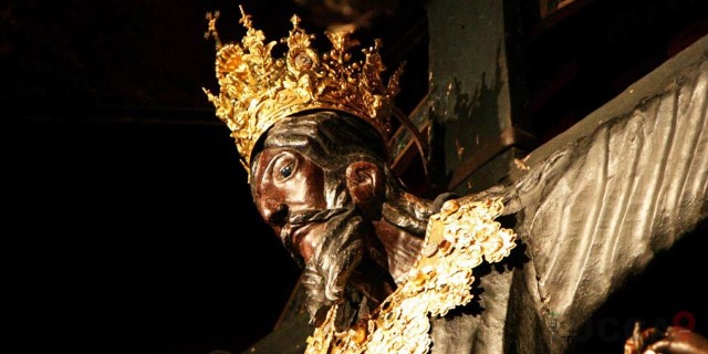
The Volto Santo (or the Holy Face of Lucca) is a Crucifix made of wood located in a small chapel within the San Martino Cathedral in Lucca. The legendary image is said to have appeared miraculously. Many critics are of the opinion that the present Volto Santo is a copy of the original which was badly damaged as a result of pilgrims breaking off pieces to take home. Current research indicates that the image was crafted between 11th and 13th century.
Il cammino
The route of the Holy Face passes through two areas, the Lunigiana and the Garfagnana which, although very different from each other, share significant historical, landscape, anthropological and geographic elements that will surprise anyone who starts walking and visits these places.
Unfortunately, the various organisations interested in establishing and promoting the route have yet to agree exactly where it should lie with the result that the paths have not generally been provided with regular CAI waymarks or direction signs at intersections. Hence, walkers should equip themselves with a good GPS before departure. The latest 4Land maps (designated: 200, 203E & 203W) all show an early draft of the route and are not to be trusted. To make matters worse, these maps do not differentiate between the hiking and MTB routes (which are generally different). Mercifully, however, the WaymarkedTrails website displays clear and up-to-date information.
Two Via del Volto Santo websites are worth visiting:
- Sul cammino del Volto Santo (Amedeo Guidugli et al)
- Via del Volto Santo (Comune di Fivizzano/Regione Toscana)
Amadeo Guidugli has written a guidebook for the walk (Il cammino del Volto Santo: Le strade e gli ospedali per pellegrini nella Valle del Serchio in epoca medievale: 2e Edizione 2016) and the stages he and his co-workers promote are:
- Stage 1: Pontremoli to Lusignana: 18km – Average travel time: 7 h
- Stage 2: Lusignana to Bagnone: 14km – Average travel time: 7 h
- Stage 3: Bagnone to Monti: 22km – Average travel time: 8 h
- Stage 4: Monti to Fivizzano: 17km – Average travel time: 6 h
- Stage 5: Fivizzano to Argegna: 20km – Average travel time: 6 h
- Stage 6: Argegna to Piazza al Serchio: 11km – Average travel time: 5 h
- Stage 7: Piazza al Serchio to Castelnuovo di Garfagnana: 21km – Av travel time: 8 h
- Stage 8: Castelnuovo di Garfagnana to Barga: 27km – Average travel time: 9 h
- Stage 9: Barga to Borgo a Mozzano: 21km – Average travel time: 8 h
- Stage 10: Borgo a Mozzano to Lucca: 28km – Average travel time: 9 h
Difficulty: E Total length: 199km Total walking time: 73hrs
In contrast, the Comune di Fivizzano/Regione Toscana promote stages as follows:
- Stage 1: Pontremoli to Bagnone: 24.5km – Average travel time: 6.5 h
- Stage 2: Bagnone to Fivizzano: 29.1km – Average travel time: 7 h
- Stage 3: Fivizzano to Argegna: 17.8km – Average travel time: 5 h
- Stage 4: Argegna to Castelnuovo di Garfagnana: 24.5km – Av travel time: 6 h
- Stage 5: Castelnuovo di Garfagnana to Barga: 14.5km – Av travel time: 3.5 h
- Stage 6: Barga to Borgo a Mozzano: 17.7km – Average travel time: 4.25 h
- Stage 7: Borgo a Mozzano to Lucca: 30.7km – Average travel time: 7.5 h
Difficulty: E Total length: 159km Total walking time: 40hrs
The differences in distances and walking times quoted for the the two versions of the route are impossible to reconcile and more experience of actual journeys is required in order to derive a realistic assessment of difficulty, distance and time. Note also that in the Serchio valley there is some overlap between the Via del Volto Santo and the Via Matildica del Volto Santo – all very confusing as can be appreciated by examining this GPX file.