Finding GIS (Geographic Infomation System) sources from which one can extract data to produce elevation profiles, contour plots and relief visualizations is no small task. As regards the Tuscany region of Italy there are two possibilities: NASA Earthdata and the Regione Toscana GeoBlog.
NASA Earthdata
The NASA Earthdata are readily available and can be loaded into the freeware product QGIS using a dedicated plugin. They are derived from RADAR surveys carried out by the space shuttle over 20yrs ago. Known as the NASA SRTM (Shuttle Radar Topography Mission) these surveys generated elevation data from the payload that was aboard Space Shuttle Endeavour during its year 2000 STS-99 mission. Full details for those interested may be found here.
During the mission, topographic data covering nearly 80% of the Earth’s land surface was obtained, creating the first-ever near-global dataset of land elevations. Originally the data for regions outside the United States were sampled for public release at 3 arc-seconds, which is 1/1200th of a degree of latitude and longitude, or about 90 meters (295 feet). Since then, new data have been released with a 1 arc-second, or about 30 meters (98 feet), sampling that reveals the full resolution of the original measurements.
NASA’s Jet Propulsion Laboratory are currently working on enhancements to the original SRTM dataset (NASADEM) which should become available as an open source product in due course.
Regione Toscana GeoBlog
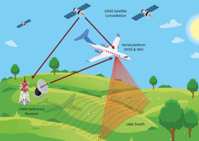
A downside of the NASA SRTM data is that it’s not particularly accurate due to the limitations of the technology available in the year 2000 and the altitude at which the measurements had to be made. Much more accurate is laser powered LiDAR (Light Detection And Ranging) data obtained from survey equipment mounted on low-flying aircraft.
As regards the UK, an excellent source of up-to-date and accurate LiDAR based elevation data available for download is the DEFRA Data Services Platform. After a great deal of searching I discovered an equivalent source for the region of Tuscany which may be accessed from its GeoBlog site.
Loading the DEFRA data into QGIS is straightforward; loading the Regione Toscana data less so. This is because the CRS (Coordinate Reference System) used for the Tuscany data is Gauss-Boaga Fuso Ovest (EPSG:3003) which, among other things, centres zero longitude at a point near Rome rather than at Greenwich. Conversion to the standard WGS84 (ESPG:4326 or EPSG:3857) CRS is straightforward, if one knows how…