
Geographical Information (GIS)
The quality of printed maps available in Italy varies enormously depending on the geographical area covered. The prime tourist areas (such as the Alps) are well documented, but the Apennines much less so. In response to an EU initiative (Directive 2007/2/EC), each region of Italy has produced Geographical Information System (GIS) data which can be accessed online. This includes information on flood plains, the distribution of flora and fauna, population density, earthquake susceptibility, footpaths etc all superimposed on monochrome maps and/or aerial photographs of the regions concerned.
To view the GIS data the most widely used free application is QGIS (previously known as Quantum GIS) which may be downloaded here. This software (which is available for Windows, Mac, Linux, BSD & Android) is extremely powerful and comprehensive, especially when used in conjunction with third party plug-ins. The learning curve is very steep, but once mastered there is little that QGIS is not capable of. Be aware, though, that no data are provided with QGIS – to make it useful one must link up to the Toscana WMS database (available here). Furthermore, the data cannot be downloaded for use offline – instead they must be viewed in real time online. Hence a fast internet connection is required if the constant redrawing of images on the screen is not to become tedious and tiring.
Be warned that the Toscana GIS data have not been updated since they were originally uploaded, and to claim they were incomplete would be a considerable understatement. For example, the footpath data relate to 2005 and incorporate only a tiny fraction of the waymarked paths observable on the ground.
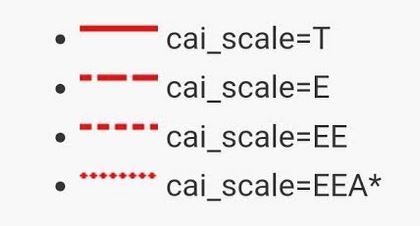
The monolithic nature of QGIS and its reliance on a high speed internet connection means that it is not well suited to many applications. Those interested in footpaths are better served by the cloud-based OpenStreetMap which is far easier to use, more up-to-date and more readily comprehensible (though often less accurate and somewhat inconsistent). A simple, clear and focussed front end to OpenStreetMap which displays walking routes in a particularly accessible format is waymarkedtrails.org – highly recommended. When using this site it’s useful to know that the appearance of the line used to display a route is directly related to the CAI’s scale of difficulty as follows:
Standalone software packages
Standalone software that can often be of use includes:
Garmin BaseCamp This (free) software is aimed at owners and users of Garmin GPS receivers. It is available in Windows and MacOS versions, but not Linux. The software allows maps, routes, tracks and waypoints to be transferred between a Garmin GPS and a PC. User-scanned custom maps and OpenStreetMap derived basemaps can be displayed – the former as overlays. Sadly, several of the most useful original features, such as Garmin’s cloud based data storage facility and adventure sharing, have now (2019) been discontinued and all development has ceased. The most recent bug-free version of the software is 4.6.2 which can be found here. Do not use the later Windows versions (eg 4.7.0 & 4.7.2) as, due to a bug, they won’t allow uploads of custom maps. The bug is reported to be corrected in MacOS version 4.8.9.
Garmin MapSource This (free) package was officially superseded by BaseCamp some years ago but is still available for download and can still be useful – particularly for correcting, joining, splitting and otherwise modifying tracks. Windows only.
QMapShack This free, open source package replicates most of the features of the Garmin BaseCamp & MapSource products and continues to be developed. Also incorporated is a facility for routing and the ability to import DEM (Digital Elevation Modelling) data. The interface is a bit clunky and the documentation could be better, but it works well enough. Available for Windows 10 & Linux (64 bit versions only).
SAS.Planet This useful freeware utility provides ready access to a range of maps many of which are based on OpenStreetMap data. There are similarities to Garmin BaseCamp but there are no track editing facilities. The SASGIS web mapping & navigation group, which is responsible for the project, is based in the Russian Federation which might put some people off.
Google Earth Pro Most people interested in maps are familiar with this (free) product which is particularly useful for calibrating custom maps as well as for producing presentation materials. It’s available in Windows, Mac and Linux versions.
GPSBabel This package allows users to convert GPS data between all the major formats. Useful from time to time to convert non-Garmin data files to gpx format for analysis/modification in BaseCamp/MapSource. Mac and Linux versions are available. Free, but donations appreciated.
GPSU This used to be a commercial product but on the retirement of its author (Alan Murphy) in 2023 was re-released as unrestricted freeware. Probably the quickest way to convert GPS data (essentially tracks and waypoints) from one coordinate reference system to another. Particularly useful for converting latitude/longitude (or Gauss-Boaga as used on the older Italian paper maps) into UTM. It will also calibrate custom maps with a level of sophistication not currently available in Google Earth. The package has been available for many years – and it shows. The interface reminds one of the MSDOS based applications of yesteryear and the graphical capabilities are crude. Don’t be fooled, though, as this software is extremely powerful and the documentation is surprisingly comprehensive. Windows only.
Microsoft Image Composite Editor Windows-only free software designed to stitch multiple images together. Powerful and accurate (but surprisingly little known). Support withdrawn by Microsoft in 2021, but works on Windows 10 and is still available for download from a number of sites.
Autodesk Design Review Free software to display and print DWF & DWFx graphics files. Useful to convert downloaded maps to PDF format from which a JPEG can be extracted (see Pixillion below). Conversion from DWG and DXF to DWF for manipulation by Design Review can be achieved by downloading the freestanding DWG TrueView package also available from Autodesk. Both packages are Windows only.
Pixillion Useful software for converting maps from one graphical format to another (typically PDF to JPEG). Commercial product with 30 day trial available. Expensive at £30 for what it is, but the conversion is extremely accurate. Available for Windows and Mac.
Web sites of interest
The following sites provide downloads of maps, GPX files etc to aid route finding:
- Via Francigena
- Trekking Lunigiana (short overview here)
- Sentiero dei Ducati
- Biking along the Via del Volto Santo
- Lunigiana Trail (MTB)
- Alpi Apuane
- General Walks
Also useful are the following sites which offer cloud-based coordinate conversion facilities, auto GPX file modification and so on:
- Conversion of Gauss Boaga to UTM
- Conversion of Latitude/Longitude to UTM
- Garmin Tools – Adding Time Stamps to GPX Files – occasionally useful when one wishes to upload non-timestamped GPX files to OpenStreetMap.